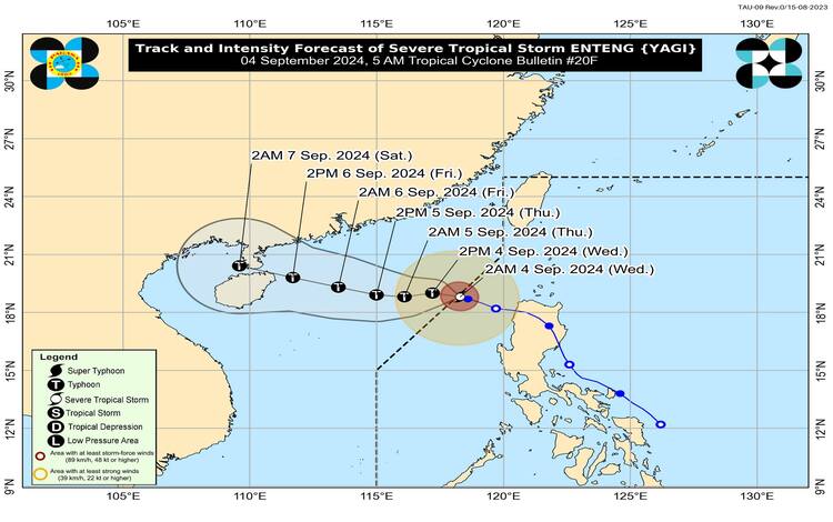
Severe Tropical Storm “ENTENG” has slightly intensified and is now outside the Philippine Area of Responsibility (PAR). The storm’s center was last estimated at 265 km west-northwest of Laoag City, Ilocos Norte, located at 18.8°N, 118.1°E. ENTENG is currently packing maximum sustained winds of 100 km/h near the center, gustiness reaching up to 125 km/h, and a central pressure of 980 hPa. It is moving slowly west-northwestward.
While ENTENG is no longer within the PAR, its effects continue to be felt in parts of the country. Strong to storm-force winds extend up to 280 km from its center, though no Tropical Cyclone Wind Signals (TCWS) are currently hoisted.
Heavy Rainfall and Enhanced Southwest Monsoon
Despite ENTENG’s exit, the enhanced Southwest Monsoon (Habagat) is expected to bring moderate to intense rainfall over several regions of Luzon, particularly along the western sections. Today, 50-100 mm of rainfall is forecasted in Ilocos Norte and Ilocos Sur, with higher accumulations in elevated or mountainous areas. Residents in these regions, especially those in areas identified as highly susceptible to flooding and rain-induced landslides, are advised to remain vigilant.
Wind Conditions
Although no wind signals are in effect, the enhanced Southwest Monsoon will bring strong to gale-force gusts across various regions, particularly in coastal and upland areas. Today, gusty conditions are expected in the Ilocos Region, Abra, Benguet, Isabela, Zambales, Bataan, Aurora, Bulacan, Metro Manila, CALABARZON, MIMAROPA, Bicol Region, Western Visayas, Negros Island, and Northern Samar. Similar conditions will persist tomorrow (September 5), extending to the same areas.
Coastal Hazards
Mariners are warned of risky sea travel conditions in the next 24 hours, especially in the northern and western seaboards of Northern Luzon, and the western seaboards of Central and Southern Luzon. Gale warnings are in effect, and sea conditions are expected to be moderate to rough, with wave heights ranging from 1.5 to 4.0 meters. Mariners of small seacrafts, including all types of motorbancas, are advised to avoid venturing out to sea.
Track and Intensity Outlook
ENTENG is forecasted to continue moving westward, potentially making landfall in southern mainland China over the weekend. The storm is expected to intensify further, possibly reaching typhoon status within the next 12 hours, and could peak in intensity by Friday, September 6, before its landfall in China.