As of 2:00 PM on September 17, 2024, Tropical Depression Gener has slightly intensified while moving over the West Philippine Sea. The latest data from the Philippine Atmospheric, Geophysical, and Astronomical Services Administration (PAGASA) indicates that Gener is 255 kilometers west-northwest of Baguio City, with coordinates at 17.0°N, 118.3°E.
Current Status
Gener’s maximum sustained winds have increased to 55 km/h, with gustiness reaching up to 70 km/h, and its central pressure is recorded at 996 hPa. The tropical depression is moving westward at a fast pace of 45 km/h, pushing the weather disturbance further away from the Philippine mainland. Gener’s winds extend outward up to 200 km from its center, impacting areas that fall within its range.
Tropical Cyclone Wind Signals
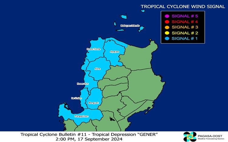
PAGASA has raised Tropical Cyclone Wind Signal (TCWS) No. 1 over several parts of Northern and Central Luzon, warning these areas of potential strong winds. The affected provinces include:
- Cagayan (northwestern portions including Pamplona, Santa Praxedes, Abulug, Sanchez-Mira, Claveria, and Ballesteros)
- Babuyan Islands
- Apayao
- Abra
- Benguet
- Ilocos Norte
- Ilocos Sur
- La Union
- Pangasinan
The TCWS No. 1 signifies that these areas could experience wind speeds between 39 km/h and 61 km/h over the next 36 hours. Winds of this strength pose minimal to minor risks to life and property, but residents are still advised to remain cautious, especially in coastal and mountainous regions.
Rainfall and Wind Threat
The heavy rainfall outlook from PAGASA indicates that Gener, along with Tropical Storm Pulasan, is enhancing the southwest monsoon, or “habagat,” leading to widespread rains. The southwest monsoon, intensified by these weather systems, will bring strong to gale-force winds across several regions, including:
- Today (September 17): Batanes, MIMAROPA, Bicol Region, Visayas, and Mindanao
- Tomorrow (September 18): Zambales, Bataan, Pampanga, Bulacan, Metro Manila, CALABARZON, MIMAROPA, Bicol Region, Visayas, and Mindanao
- Thursday (September 19): Isabela, Aurora, Pangasinan, Zambales, Bataan, Metro Manila, CALABARZON, MIMAROPA, Bicol Region, and Western Visayas
Severe winds are anticipated mainly in exposed coastal and upland areas, where gusts could be stronger due to the geography. Even areas under TCWS No. 1 are likely to experience moderate winds capable of causing minor impacts.
Hazards at Sea
PAGASA has issued a Gale Warning over several coastal areas, particularly the northern seaboard of Northern Luzon, the western and southern seaboards of Southern Luzon, the seaboards of Visayas, and the western, northern, and eastern seaboards of Mindanao. Seas in these areas are expected to be rough to very rough, with wave heights ranging from 1.0 to 3.0 meters.
Mariners of small seacrafts and motorbancas are strongly advised against venturing out into these seas due to the risk of dangerous conditions. Coastal waters not covered by the Gale Warning may still experience moderate to rough seas, so caution is advised even in these areas.
Track and Forecast
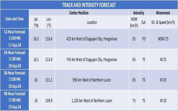
According to the latest track forecast, Tropical Depression Gener is expected to exit the Philippine Area of Responsibility (PAR) tonight or early tomorrow morning (September 18). Once outside PAR, it will continue its westward movement across the West Philippine Sea. While some slight intensification is possible, Gener is not expected to become a significantly stronger system, although it could reach tropical storm status by tomorrow morning.
PAGASA continues to monitor the situation closely and advises the public to remain updated on future bulletins, especially with the enhancement of the southwest monsoon bringing potential heavy rainfall and winds in several parts of the country. The next update will be issued at 5:00 PM today.