Issued at 5:00 AM, 18 September 2024
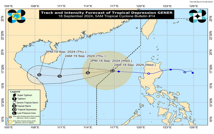
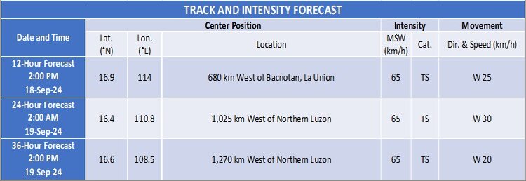
Tropical Depression GENER, which has recently been affecting parts of the Philippines, is now officially outside the Philippine Area of Responsibility (PAR). The weather system was last observed at 4:00 AM today, with its center located approximately 410 kilometers west of Bacnotan, La Union, at coordinates 17.4°N latitude and 116.6°E longitude.
Current Intensity and Movement
As of the latest update, GENER has maximum sustained winds of 55 km/h near its center, with gustiness reaching up to 70 km/h. The system’s central pressure stands at 996 hPa. GENER is moving westward at a speed of 15 km/h. The tropical cyclone’s wind field extends outwards up to 360 kilometers from its center, though there are no Tropical Cyclone Wind Signals (TCWS) currently in effect.
Impact on Land Areas
Despite being outside the PAR, GENER continues to influence weather patterns through its interaction with the Southwest Monsoon. The enhanced monsoon is expected to bring significant weather impacts:
- Today: Areas including Zambales, Bataan, Pampanga, Bulacan, Metro Manila, CALABARZON, MIMAROPA, the Bicol Region, the Visayas, Zamboanga Peninsula, Northern Mindanao, Caraga, and the Davao Region will experience strong to gale-force gusts.
- Tomorrow (19 September): The affected areas will extend to the Ilocos Region, Isabela, Aurora, Zambales, Bataan, Metro Manila, CALABARZON, MIMAROPA, the Bicol Region, Western Visayas, Negros Island Region, and Zamboanga Peninsula.
- Thursday (20 September): The gusty conditions will further include the Ilocos Region, Isabela, Aurora, Zambales, Bataan, Cavite, Batangas, Quezon, Occidental Mindoro, Marinduque, and Romblon.
The Southwest Monsoon, also influenced by Tropical Depression HELEN, is expected to bring heavy rainfall and strong winds to these areas. For detailed rainfall forecasts, refer to Weather Advisory No. 31 issued this morning.
Coastal Waters and Sea Conditions
Gale warnings are currently in effect for several coastal waters along the western seaboard of Central Luzon, Southern Luzon, and the Visayas. Sea travel in these regions is deemed risky, particularly for small seacrafts and motorbancas. The Gale Warning No. 8 issued at 5:00 AM today highlights these hazards.
Other coastal areas outside the Gale Warning zones may experience rough seas with wave heights ranging from 1.0 to 3.5 meters. This includes the northern seaboards of Cagayan Valley and Zamboanga Peninsula, as well as various seaboards in Caraga, Ilocos Region, Bicol Region, Davao Region, Eastern Visayas, CALABARZON, and Negros Island Region. Mariners of small seacrafts are advised to avoid venturing out under these conditions.
Moderate seas, with heights up to 2.5 meters, are expected along the remaining seaboards of the country. Mariners are urged to exercise caution and avoid sea travel if conditions are unfavorable.
Future Outlook
As GENER continues its westward trajectory over the West Philippine Sea, it is heading towards Vietnam. The system is forecasted to undergo limited intensification, with a possibility of reaching tropical storm strength later today.
Residents and maritime users are advised to stay updated on the latest weather advisories and warnings to ensure safety and preparedness in the face of changing weather conditions.