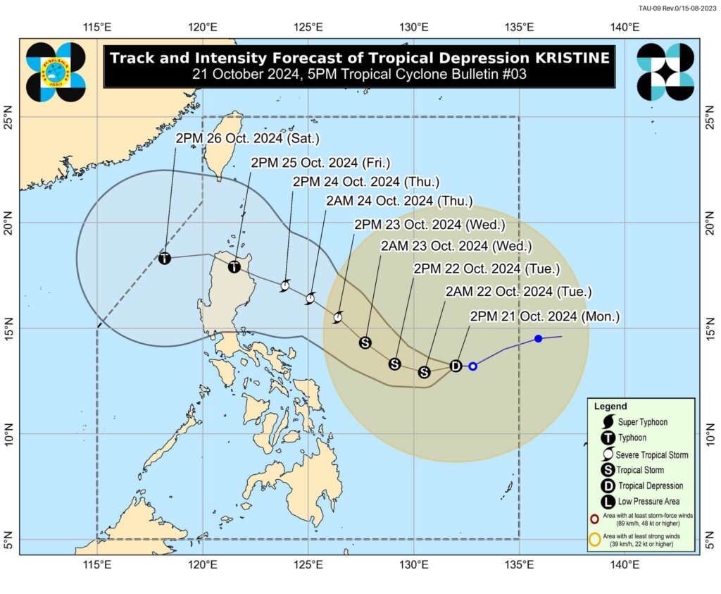
Tropical Depression “Kristine” has slightly decelerated as it continues to move westward over the Philippine Sea. As of 4:00 PM today, the center of “Kristine” was located approximately 760 km east of Catarman, Northern Samar, with coordinates of 13.2°N, and 131.6°E. The system maintains maximum sustained winds of 55 km/h near the center, gusts of up to 70 km/h, and a central pressure of 998 hPa.
Current Movement and Intensity
Kristine is moving westward at a speed of 15 km/h. Strong winds extend up to 800 km from its center, affecting various regions.
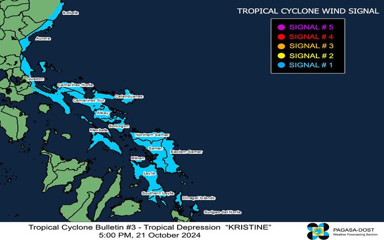
Tropical Cyclone Wind Signals (TCWS) in Effect
TCWS No. 1 has been raised over the following areas, indicating the threat of strong winds within the next 36 hours:
- Luzon: Southeastern Isabela (Palanan, Dinapigue), Aurora, parts of Quezon including Pollilo Islands, Camarines Norte, Camarines Sur, Catanduanes, Albay, Sorsogon, and Masbate including Ticao and Burias Islands.
- Visayas: Eastern Samar, Northern Samar, Samar, Leyte, Biliran, and Southern Leyte.
- Mindanao: Dinagat Islands and Surigao del Norte, including Siargao and Bucas Grande.
Potential Impacts of Winds
The winds associated with TCWS No. 1 pose a minimal to minor threat to life and property. However, stronger winds may affect coastal and upland areas, especially those exposed to the cyclone’s wind flow and the Northeasterly flow.
Severe Winds and Gale Warnings
Strong to gale-force gusts are expected in the following areas:
- Today (21 October): Batanes, Ilocos Norte, Cagayan, parts of Palawan, and parts of Visayas and Mindanao.
- Tomorrow (22 October): Batanes, Babuyan Islands, Ilocos Norte, Ilocos Sur, and more regions across the country.
- Wednesday (23 October): MIMAROPA, Visayas, and Mindanao.
A Gale Warning has been issued for the eastern seaboards of Southern Luzon and Visayas, with sea conditions forecasted to be very rough (up to 5.5 meters) over the northern and eastern seaboards of the Bicol Region and other affected coastal areas. Mariners are advised not to venture out to sea under these conditions, especially if operating small vessels.
Track and Intensity Outlook
Kristine is expected to continue its west-southwestward movement until tomorrow morning (22 October) before shifting to a west-northwestward direction. It may make landfall in Northern Luzon on Thursday evening (24 October) or Friday morning (25 October). There remains a possibility of Kristine intensifying into a tropical storm in the next 12 hours and potentially reaching severe tropical storm or typhoon strength by Wednesday or Thursday.
Heavy Rainfall Outlook
Moderate to heavy rains are anticipated over Eastern Samar, Samar, Biliran, Leyte, Southern Leyte, and parts of Cebu, which may persist for the next 2 to 3 hours. Residents in affected areas are advised to monitor updates and prepare for possible flooding or landslides.
Stay tuned for further updates as Tropical Depression Kristine continues to develop.