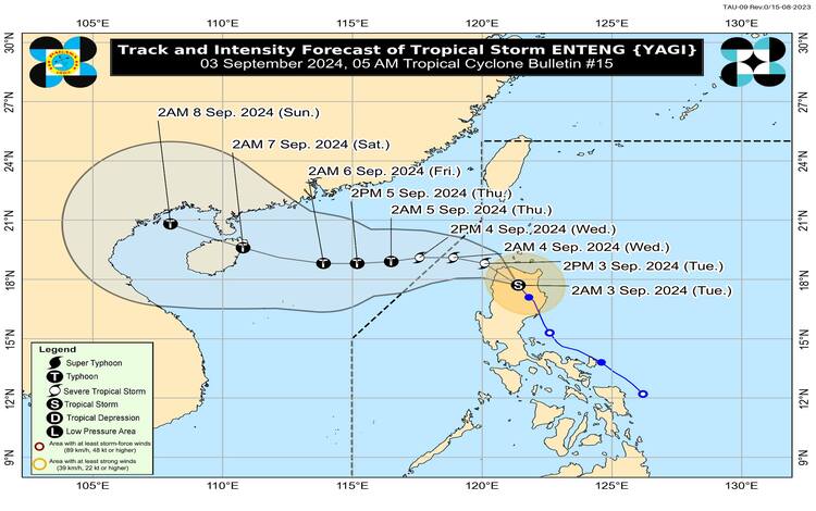
As of 4:00 AM today, Tropical Storm “Enteng” was located over the coastal waters of Paoay, Ilocos Norte, with coordinates 18.1°N, 120.4°E. The storm has intensified, now carrying maximum sustained winds of 75 km/h near its center and gustiness reaching up to 125 km/h, with a central pressure of 994 hPa. “Enteng” is moving northwestward at a speed of 25 km/h.
Wind Signals and Affected Areas
The Philippine Atmospheric, Geophysical and Astronomical Services Administration (PAGASA) has issued Tropical Cyclone Wind Signals (TCWS) across several regions due to the threat posed by “Enteng.”
- TCWS No. 2 has been raised over Ilocos Norte, the northern portion of Ilocos Sur, Apayao, Abra, Kalinga, and the western portion of Mainland Cagayan, including the Babuyan Islands. These areas can expect gale-force winds with speeds ranging from 62 to 88 km/h within the next 24 hours, posing a minor to moderate threat to life and property.
- TCWS No. 1 is in effect over the rest of Ilocos Sur, the northern portion of La Union, Mountain Province, Ifugao, northern Benguet, Batanes, the rest of Mainland Cagayan, the rest of Babuyan Islands, Isabela, northern Nueva Vizcaya, and northern Quirino. These areas will experience strong winds with speeds between 39 to 61 km/h, with a minimal to minor threat to life and property.
Rainfall and Flooding Concerns
“Enteng” is expected to bring significant rainfall across Northern Luzon. For today, the Ilocos Region may experience 100-200 mm of rainfall, while the Cagayan Valley and Cordillera Administrative Region may see 50-100 mm. Tomorrow, Ilocos Norte is forecasted to receive another 50-100 mm. Given the mountainous terrain in these regions, there is an elevated risk of flooding and rain-induced landslides, particularly in areas already saturated from previous rains.
Additionally, the enhanced Southwest Monsoon will cause moderate to intense rainfall across other parts of Luzon, especially along the western regions, over the next three days.
Coastal and Marine Warnings
PAGASA has issued a Gale Warning for the seaboards of Northern and Central Luzon due to the combined effects of “Enteng” and the Southwest Monsoon. Sea travel is risky for small seacrafts, including motorbancas, with rough seas expected over these areas.
Track and Intensity Outlook
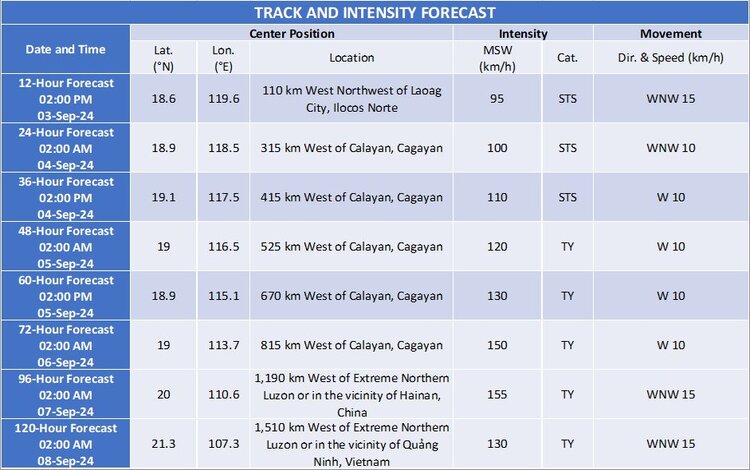
Tropical Storm “Enteng” is projected to continue its northwestward trajectory, potentially exiting the Philippine Area of Responsibility by tomorrow morning. The storm is expected to intensify into a severe tropical storm by this afternoon or evening and may reach typhoon status by Thursday, September 6.
Residents in affected areas are advised to remain vigilant, heed official warnings, and prepare for possible evacuation if necessary. PAGASA continues to monitor the situation and will provide updates as necessary.