As of 3:00 PM today, PAGASA has provided crucial updates on Tropical Storm “Julian” (local name: Krathon) and Tropical Storm “Jebi” (international name: 2417), highlighting their current locations, intensity, and the potential impacts they bring to affected areas across the country.
Tropical Storm “Julian” (Krathon) Update
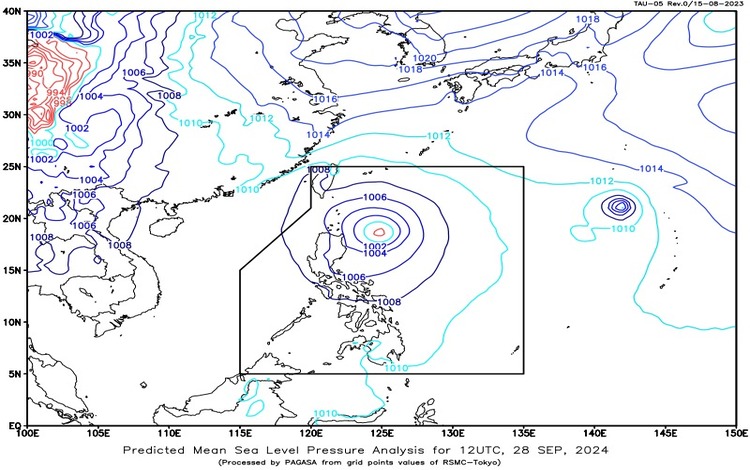
The center of Tropical Storm “Julian” is currently located approximately 390 km east of Aparri, Cagayan, at coordinates 18.6°N, 125.3°E. The storm has maximum sustained winds of 75 km/h near its center and gustiness reaching up to 90 km/h. It is moving west-northwestward at a speed of 15 km/h, slowly inching closer to northern Luzon.
PAGASA has warned that the storm will bring heavy rainfall and gusty winds to parts of Northern and Central Luzon, prompting advisories for possible flash floods and landslides in high-risk areas.
Tropical Storm “Jebi” Update
Meanwhile, Tropical Storm “Jebi” is still located outside the Philippine Area of Responsibility (PAR), approximately 2,170 km east of Extreme Northern Luzon, at coordinates 20.8°N, 142.8°E. The storm is moving north-northwestward at 20 km/h, with maximum sustained winds of 75 km/h and gustiness of up to 90 km/h.
PAGASA noted that while Jebi remains far from the country’s landmass, it will continue to be monitored for any changes that might affect the Philippines. The storm is expected to track northwards, moving away from Philippine territory, although it could still cause enhanced monsoon conditions over the next few days.
Weather Forecast and Impact for Affected Areas
The following are the weather forecasts and potential impacts for regions expected to experience Julian’s effects:
- Batanes, Cagayan (including Babuyan Islands), Isabela, Apayao, and Ilocos Norte
- Weather Condition: Rains with gusty winds
- Cause: Direct impact of Tropical Storm Julian
- Impacts: Potential flash floods or landslides due to moderate to heavy rainfall, especially during intense downpours. Strong winds pose a minimal to minor threat to lives and property.
- Central Luzon, Quezon, Camarines Norte, Camarines Sur, Catanduanes, Ilocos region, Cordillera Administrative Region, and Cagayan Valley
- Weather Condition: Cloudy skies with scattered rains and thunderstorms
- Cause: Indirect effects of Tropical Storm Julian
- Impacts: Potential flash floods or landslides due to moderate to heavy rains in vulnerable areas.
- Metro Manila and the rest of the country
- Weather Condition: Partly cloudy to cloudy skies with isolated rain showers or thunderstorms
- Cause: Localized thunderstorms
- Impacts: Possible flash floods or landslides in low-lying areas during severe thunderstorms.
Wind and Coastal Water Conditions
- Northern Luzon: Strong winds coming from the northwest to southwest will create rough coastal waters, with wave heights reaching 2.8 to 4.0 meters. These conditions pose risks to small vessels, particularly in Batanes, Babuyan Islands, and the northern coastal regions of Luzon.
- Central Luzon and Eastern Southern Luzon: Moderate to strong winds from the northwest to southwest will cause moderate to rough seas, with waves between 2.1 to 3.0 meters.
- Rest of the country: Winds will generally be light to moderate, coming from the west to southwest, with slight to moderate coastal waters ranging from 0.6 to 2.5 meters.
Precautionary Measures
PAGASA urges residents in affected areas, particularly those in landslide-prone and low-lying areas, to remain vigilant and heed the advisories of local disaster risk reduction and management offices. Fisherfolk and small seacraft operators are advised not to venture out into the sea, especially in areas with rough coastal waters.
Outlook
Tropical Storm Julian is forecasted to continue its west-northwestward trajectory, potentially affecting more areas in Northern Luzon over the coming days. However, its current intensity and movement do not suggest an immediate threat of a direct landfall.
Meanwhile, Tropical Storm Jebi, though outside the PAR, will still be monitored closely for any further developments that might impact the country. PAGASA will continue issuing updates as both tropical cyclones evolve.