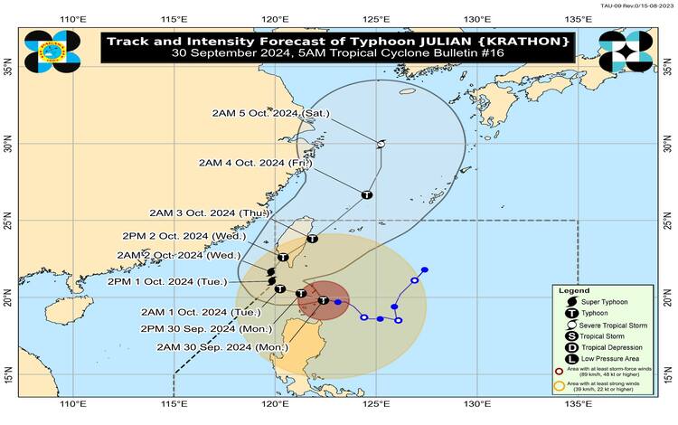
Typhoon Julian continues to unleash powerful winds and heavy rainfall as it moves over the Balintang Channel, affecting Batanes and the northeastern Babuyan Islands. This severe weather system, packing maximum sustained winds of 155 km/h and gusts reaching 190 km/h, is currently located near Balintang Island, Calayan, Cagayan. The storm is moving westward at a slow 10 km/h, with typhoon-force winds extending up to 560 kilometers from its center.
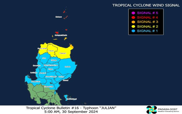
Tropical Cyclone Wind Signals (TCWS) in Effect
The Philippine Atmospheric, Geophysical, and Astronomical Services Administration (PAGASA) has raised various wind signals in Luzon. These signals serve as warnings to the public about the threat posed by Julian’s violent winds:
- TCWS No. 4: Batanes and northern Babuyan Islands are under this signal, warning of typhoon-force winds ranging from 118 to 184 km/h. Severe impacts on life and property are expected, with the peak of the storm hitting between this morning and the afternoon.
- TCWS No. 3: The rest of the Babuyan Islands and the northeastern part of mainland Cagayan, including Santa Ana, are facing storm-force winds between 89 to 117 km/h, with moderate to significant impacts anticipated.
- TCWS No. 2: Gale-force winds of 62 to 88 km/h are forecasted in mainland Cagayan, Apayao, and Ilocos Norte, where minor to moderate threats to life and property are expected.
- TCWS No. 1: Areas including Ilocos Sur, La Union, Pangasinan, and parts of Nueva Ecija, among others, may experience strong winds of 39 to 61 km/h, posing minimal threats.
Severe Winds and Heavy Rainfall
PAGASA warns that areas under TCWS No. 4 will experience typhoon-force winds with potentially life-threatening impacts. Those under TCWS Nos. 3, 2, and 1 will face less severe, but still dangerous, wind conditions. Winds are expected to be especially strong in coastal and upland areas, where natural wind barriers are limited.
In addition to high winds, heavy rainfall is a major concern. PAGASA’s latest advisory forecasts torrential rain in northern Luzon, heightening the risk of floods and landslides. The hardest-hit areas include Batanes, the Babuyan Islands, Cagayan, and Apayao.
Coastal Hazards and Gale Warnings
The risk of storm surge is particularly high in low-lying and coastal areas of Batanes, the Babuyan Islands, and northern Cagayan. Residents in these areas are urged to take precautions as coastal inundation could lead to significant flooding.
PAGASA has issued Gale Warning No. 6, cautioning against sea travel due to rough and very high seas. Mariners are advised to stay in port or seek shelter as waves may reach heights of up to 14.0 meters in Batanes and 10.0 meters in Babuyan Islands. Even smaller boats face significant risk in waters around Ilocos Norte and Cagayan, with sea conditions remaining hazardous until the typhoon passes.
General Flood Advisories
Issued @6AM, 30 September 2024
CAR (Cordillera Administrative Region) GFA#6
Region 1 (Ilocos Region) GFA#6
Region 2 (Cagayan Valley) GFA#7
Region 3 (Central Luzon) GFA#3
Region 4A (CALABARZON) GFA#2
Region 4B (MIMAROPA ) GFA#2
Region 5 (Bicol Region) GFA#2
Track and Intensity Outlook
Typhoon Julian is expected to continue moving west-northwestward over the Balintang Channel today, passing close to Balintang Island and Batanes. It may make landfall in these areas later this morning or afternoon. Julian will begin to recurve northeastward tomorrow, potentially leaving the Philippine Area of Responsibility (PAR) on Wednesday before making landfall in Taiwan. The typhoon is forecast to intensify further, potentially reaching super typhoon status before interacting with Taiwan’s mountainous terrain, which could weaken it.
Residents in the affected areas are advised to stay vigilant, heed local authorities’ warnings, and prepare for the potentially devastating impacts of Typhoon Julian.