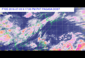
A tropical depression has intensified into a storm off the Pacific Ocean is expected to land the Philippine Area of Responsibility (PAR) tomorrow, according to the weather bureau.
Yesterday as of 4 PM, the tropical depression with the international name Pepartak, was seen at 2,060 kilometers east of Mindanao.

The disturbance has a wind of 65 kilometers per hour near the center and the gustiness of 80 kilometers per hour and was forecast to move northwest at seven kilometers per hour.
Once entered the Philippine Area of Responsibility (PAR), the storm will be locally called “Butchoy.”
Basing on its movement, the tropical depression has a low chance of making a landfall, according to the Philippine Atmospheric, Geophysical and Astronomical Services Administration (PAGASA).
According to the PAGASA, the tropical depression Nepartak might not affect any part of the country in the next 5 days.
Tomorrow, the tropical depression is projected to be at 2, 030 kilometers east of Visayas today and 2,000 km east of Luzon tomorrow morning.
On Wednesday, the storm will be at 1, 070 km east of ITbayat, Batanes and at 1,030 km northeast of the province Thursday morning.
Yesterday, PAGASA spotted a low-pressure area somewhere 85 km east of Catarman, Northern Samar.
It was linked along the ITCZ, it said.
The low-pressure area is expected to bring cloudy skies with moderate to occasionally heavy rains over Bicol and Samar until today.
Metro Manila, Cagayan, Laguna, Rizal, Quezon, Mindoro, Batangas, Pangasinan, Tarlac as well as Central Luzon, Northern Mindanao, and some Visayan provinces will be experiencing light to moderate rains and thunderstorms.
So what can you say about this one? Let us know your thoughts in the comment section below and don’t forget to share this blog post with your family and friends using Facebook and Twitter. Also, don’t forget to visit our website and Facebook page more often for more updates.
