The Philippine Atmospheric, Geophysical and Astronomical Services Administration (PAGASA) released its 5:00 p.m. weather bulletin on June 10, 2025, highlighting the continuing impact of the Southwest Monsoon or habagat over Central and Southern Luzon, Visayas, and Mindanao. The monsoon is currently being enhanced by a tropical depression located outside the Philippine Area of Responsibility (PAR).
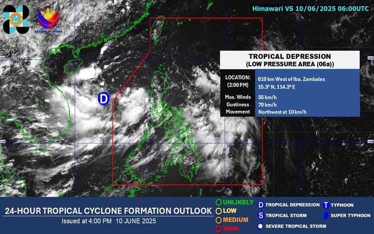
As of 3:00 p.m. today, the tropical depression was spotted approximately 610 kilometers west of Iba, Zambales. It carries maximum sustained winds of 55 kilometers per hour and gustiness of up to 70 kilometers per hour. It is moving northwestward at a speed of 10 km/h. While it poses no direct threat to the country, its presence is intensifying the monsoon rains across several regions.
Affected Areas and Weather Conditions
PAGASA forecasts occasional rains in Cavite, Batangas, Zambales, Bataan, Occidental Mindoro, and Palawan, which may potentially trigger flash floods or landslides, especially in low-lying and mountainous areas.
Meanwhile, Metro Manila, the Visayas, the Bicol Region, Central Luzon, CALABARZON, and MIMAROPA will experience cloudy skies with scattered rains and thunderstorms, all due to the Southwest Monsoon. Residents in these areas are also warned of possible flooding and landslides.
Mindanao and the rest of Luzon are expected to have partly cloudy to cloudy skies with isolated rain showers or thunderstorms. While generally fair, severe thunderstorms in these areas may still result in localized flooding and landslides.
Wind and Sea Conditions
Moderate to strong southwesterly winds are expected over the western sections of Southern Luzon and the Visayas, leading to moderate to rough coastal waters (1.2 to 3.0 meters). The northern and central parts of Luzon will experience lighter winds and slightly moderate seas (0.6 to 2.1 meters), while similar conditions are expected in the rest of the country.
Rainfall Outlook
From today until tomorrow afternoon (June 11), Zambales, Bataan, Cavite, Batangas, Occidental Mindoro, and Palawan may receive 50 to 100 mm of rainfall. By tomorrow afternoon to Thursday (June 12), rainfall is expected to increase, with 100 to 200 mm forecasted in Occidental Mindoro, Zambales, and Bataan. Additional rainfall of 50 to 100 mm is anticipated in Metro Manila, Pangasinan, and several provinces in CALABARZON, MIMAROPA, and Western Visayas.
Public Warnings and Advisories
PAGASA advises the public and local government units to remain vigilant, especially in areas with significant antecedent rainfall, as conditions may worsen quickly. Heavy Rainfall Warnings may be issued at the municipal level using real-time radar data, while broader Weather Advisories are given at the provincial level with a 24-hour outlook.
As of 6:00 p.m., General Flood Advisories have been issued for the following regions: Ilocos Region (GFA#1), Central Luzon (GFA#24), CALABARZON (GFA#7), MIMAROPA (GFA#12), Western Visayas (GFA#14), and Eastern Visayas (GFA#10).