MANILA, Philippines — The Philippine Atmospheric, Geophysical and Astronomical Services Administration (Pagasa) issued its 3:00 PM weather forecast today, June 9, 2025, warning of widespread rains and possible hazards as a Low Pressure Area (LPA) continues to linger west of Northern Luzon.
According to Pagasa, the LPA was estimated at 415 kilometers west of Bacnotan, La Union (16.5°N, 116.5°E). Although it remains outside the Philippine Area of Responsibility (PAR), its influence, combined with the prevailing southwest monsoon or habagat, is bringing significant rainfall over large portions of the country.
Rainy Weather Over Luzon, Visayas, and Mindanao
Occasional rains are expected to persist over Zambales, Bataan, Cavite, Batangas, Occidental Mindoro, and Palawan. These weather conditions are due to the strengthening effects of the southwest monsoon. Residents in these areas are advised to prepare for possible flash floods and landslides due to moderate to heavy rains.
Meanwhile, Metro Manila, the rest of Central Luzon, CALABARZON, MIMAROPA, the Bicol Region, and most of the Visayas can expect cloudy skies with scattered rains and thunderstorms. The same warning applies: the rainfall could become heavy at times, potentially triggering localized flooding or landslides.
In Mindanao, the weather will be partly cloudy to cloudy, with isolated rain showers and thunderstorms possible, especially during late afternoon and evening hours. These isolated events could still bring heavy rains, prompting warnings of flash floods or landslides during severe thunderstorms.
Localized thunderstorms are also expected to affect the remaining parts of Luzon, with similar warnings for sudden downpours and possible hazards in low-lying and mountainous areas.
Wind and Coastal Conditions
Pagasa also reported moderate to strong southwest winds across the western sections of Southern Luzon and Visayas, resulting in mild to rough seas (1.2 to 2.8 meters). Fishing boats and small seacraft are advised to exercise caution.
For Northern and Central Luzon, winds will be light to moderate from the south to southeast, with slight to moderate seas ranging from 0.6 to 2.1 meters. The rest of the country will experience similar wind and sea conditions, with winds blowing from the south to southwest.
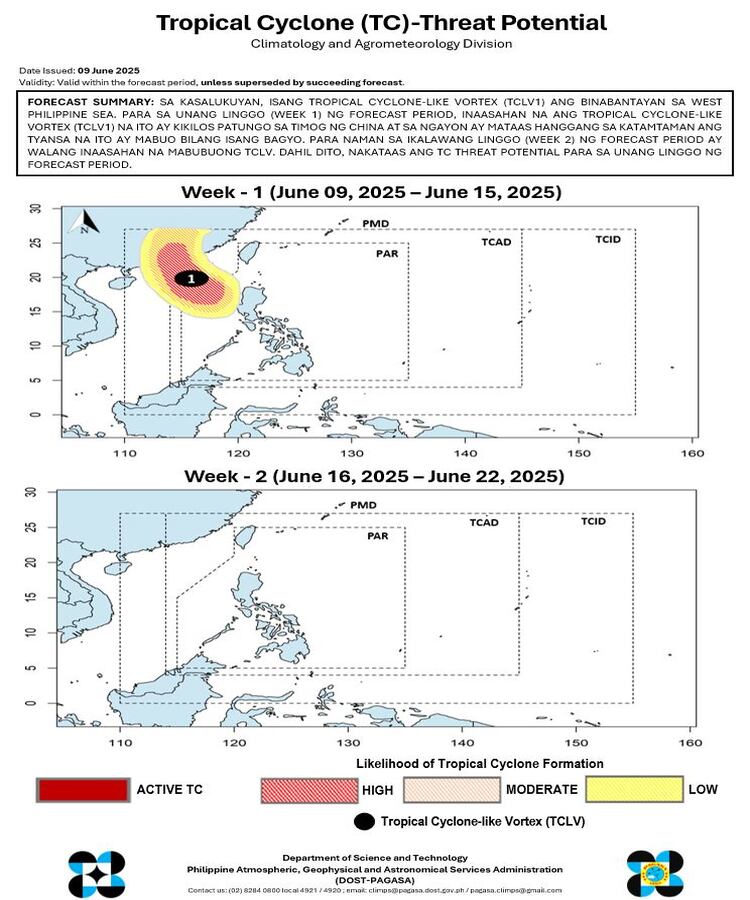
Tropical Cyclone Threat on the Horizon
In its Tropical Cyclone Threat Potential Forecast, Pagasa reported the presence of a Tropical Cyclone-Like Vortex (TCLV1) over the West Philippine Sea. For the first week of the outlook period (June 9–15), the system is forecast to move toward southern China. There is currently a moderate to high chance that it will develop into a tropical cyclone. No such systems are expected during the second week (June 16–22).
Flood Advisories Raised in Several Regions
As of 6:00 PM today, Pagasa raised general flood advisories across multiple regions, including Central Luzon (Region 3), CALABARZON (Region 4A), MIMAROPA (Region 4B), Western Visayas (Region 6), Eastern Visayas (Region 8), and various regions in Mindanao.
Pagasa urges the public to remain vigilant, monitor updates, and heed local government warnings as rainfall may continue in the coming days.