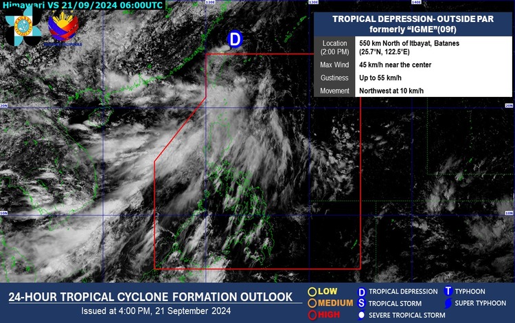
As of 3:00 PM today, Tropical Depression “Igme” (formerly a named storm) is located outside the Philippine Area of Responsibility (PAR), approximately 550 kilometers north of Itbayat, Batanes, at coordinates 25.7°N, 122.5°E. The tropical depression has maximum sustained winds of 45 km/h near the center, with gusts of up to 55 km/h. It is moving northwestward at a speed of 10 km/h, slowly heading farther away from the country.
Forecasted Weather Conditions:
The Southwest Monsoon (Habagat) continues to affect large parts of the country, particularly the northern and western sections of Luzon and the Western Visayas. The following areas are expected to experience various weather conditions:
- Batanes and Babuyan Islands will have occasional rains due to the effects of the monsoon. Residents are advised to be alert for possible flash floods or landslides as rains could range from moderate to heavy in intensity.
- Metro Manila, the rest of Luzon, and Western Visayas will experience cloudy skies with scattered rain showers and thunderstorms. The monsoon will likely cause periods of heavy rainfall, increasing the risk of flash floods and landslides in vulnerable areas.
- The rest of the country can expect partly cloudy to cloudy skies with isolated rain showers or thunderstorms caused by localized thunderstorms. While rains may be less frequent, severe thunderstorms could still trigger flash floods and landslides in affected areas.
Wind and Coastal Water Conditions:
The northern and western sections of Northern Luzon will experience strong winds coming from the southwest, accompanied by rough coastal waters with waves ranging from 2.8 to 4.0 meters in height.
For the rest of Luzon, wind speeds will range from moderate to strong coming from the south to southwest, resulting in moderate to rough seas with waves between 2.5 to 3.4 meters.
In contrast, the rest of the country will have light to moderate winds from the southeast to southwest, with light to moderate seas where wave heights will range from 0.6 to 2.5 meters.
Tropical Cyclone Outlook:
As of 4:00 PM today, no other low-pressure areas (LPAs) are being monitored for potential tropical cyclone formation. However, residents in affected areas should remain cautious due to the ongoing impact of the Southwest Monsoon.